Monday, June 24, 2024

Whitehall, NY to Orwell, VT. Lake Champlain. First stop in Vermont

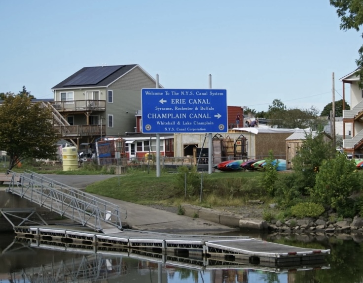
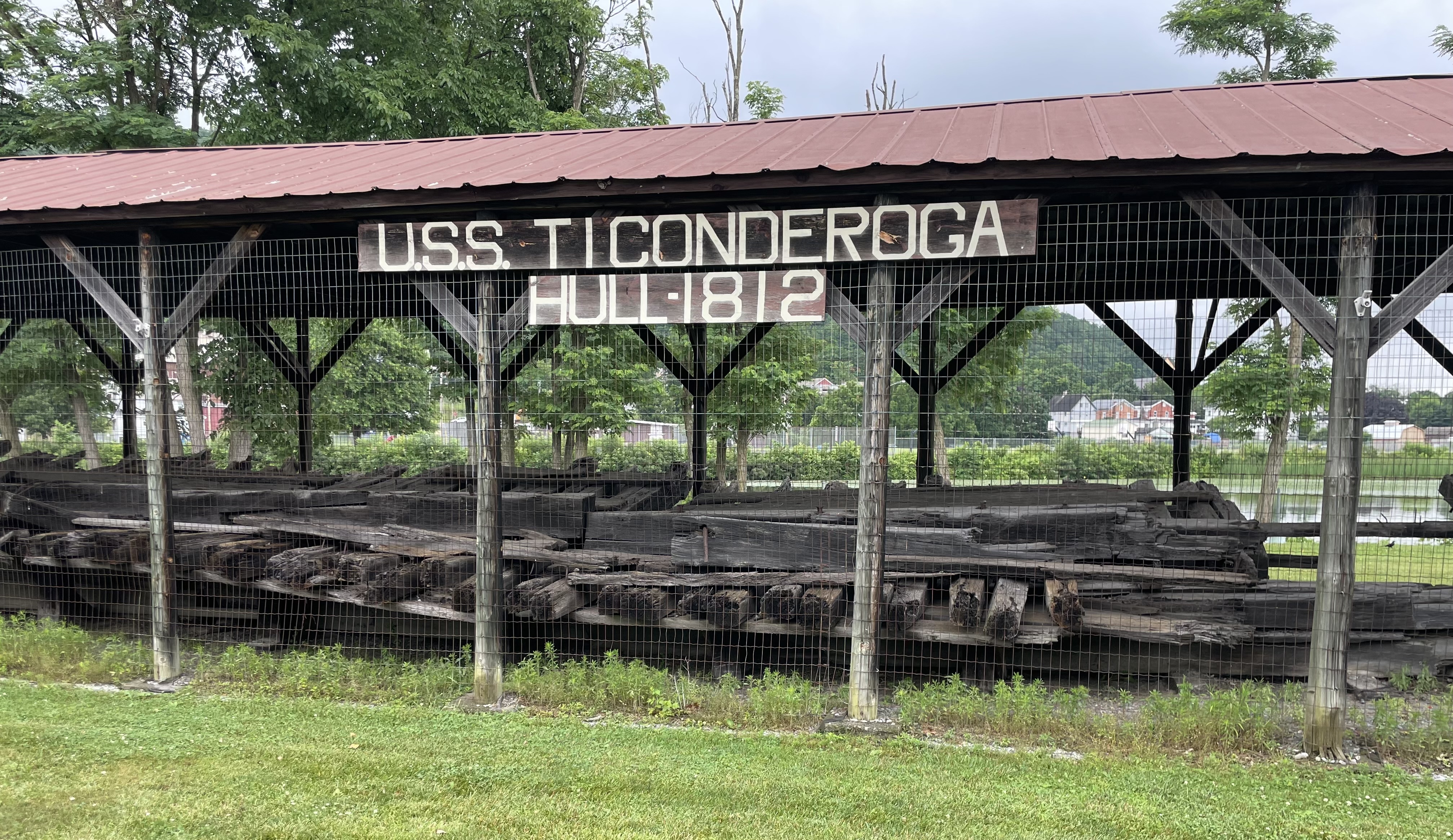
Sunday was another morning of waking up, immediately checking the weather forecast and then deciding what to do. And it was another day of opting to travel early to avoid afternoon storms. Before leaving Whitehall, we went to see the resurrected hull of the USS Ticonderoga, an 1812 sloop in the American Navy that was salvaged from the bottom of Lake Champlain in 1958 and is now on display.


We departed Whitehall and immediately went through Lock 12, our last on the Champlain Canal, and entered Lake Champlain. Sometimes called “The Sixth Great Lake,” it is 107 miles long and 14 miles at its widest point. Named for Samuel de Champlain, who first explored here in 1609, it is renowned for its natural beauty and so far has not disappointed. The southern part of the lake is more like a river, with swampy and marshy banks, mostly wild but sprinkled with a cottage here and there. The Adirondack Mountains are on our left and the Green Mountains of Vermont are starting to appear on our right. Birds are everywhere, and we regularly spot kingfishers, cormorants, heron, gulls, terns, eagles and osprey, which love to nest in the navigation markers. 


We traveled 19 miles with a moderate tailwind and following seas, to Chipman Point Marina in Orwell, our first stop in Vermont. This family-run outfit has a super laid-back vibe and we really enjoyed our stay here, despite the motion on the docks from wind, waves and wakes. There was a severe thunderstorm warning and a brief tornado watch, which ended up being nothing more than several waves of rain showers. We dared not walk into the town, three miles away, and did laundry, played games, ate dinner onboard and went to bed early. Map Link: Chipman Point, VT


Saturday, June 22, 2024

Fort Ann to Whitehall, NY

The rain let up this morning, so Kathleen got to go for a run along the Empire State Trail, I did some exploring and we both got some good pics of the pretty park we’re staying in. The start of the bike trail goes through the old canal where Locks 16 and 17 once stood.


My first stop was Fort Ann Battlefield, now a farmer’s field. In the summer of 1777, the retreating Colonial Army slowed the British invasion from the north enough to allow better defenses to be built and reinforced in Saratoga, trading a small defeat in Fort Ann for a decisive victory at Saratoga.  


It was another day where we squeezed some forward progress into a small weather window. We left Fort Anne at 9:00 AM in a light rain, traveled 11 miles and through one lock, and arrived at Whitehall in light rain. We got the last spot in front of a power pedestal at the town wall, but ended up sharing it with a Canadian sailboat that had a long extension cord. The wall is fairly full, and includes two large sailing cruisers carrying their masts and a Catalina 25 sailboat with no mast (bottom of pic), the first no-masted sailboat besides ours that we’ve seen since Dubuque, IA, last September.  


Not wanting to sit inside the boat through more rain, we quickly disembarked to visit the local museum, which is about 200 feet away from the dock. Whitehall claims to be the birthplace of the U.S. Navy, where a fleet of small ships was built in 1776 to battle for control of Lake Champlain. Fun fact (and disclosed by the museum staff): At least three other American locations make identical claims to building the first Navy vessels. The museum was incredible, with over 4,000 artifacts documenting local history of the canal, lake, wars and life in this area. Map Link: Whitehall, NY


Whitehall was originally called Skenesborough, after Phillip Skene, a retired British Army officer who settled here, built a sawmill and just about everything else. His home, Skene Manor, is the beautiful Victorian Gothic on the hill overlooking the town. He was a fierce British loyalist and opposed American independence, so while his significant legacy is preserved here, the town was renamed in 1786.


Today was our lucky day, as Whitehall was hosting a summer festival in the park next to our dock. The rain let up around 4;00 PM and we strolled around the booths, ate tacos and burritos from a school-bus converted to a food truck and listened to the Whiskey River Band, a local, over-60 cover group. Lastly, we watched an impressive fireworks show from our folding chairs on the wall next to our boat. The booming echos of the explosions off of the nearby hills was a new experience and one we’ll always remember.


Photo Journal:
We don’t understand this motto

Just loved this name

Tire snowmen don’t melt


Friday, June 21, 2024

Lock Closure. Fort Edward to Fort Ann, NY

We regularly receive e-mail updates from the New York Canal Corporation, called “Notice to Mariners” with issues concerning locks, bridges and hazards to navigation on the state’s canals. Almost every day there is a problem somewhere, and we knew it was just a matter of time before it would be our turn to be impacted. Last night there was a power outage at Champlain Canal Lock 9, in Smith’s Basin, NY, and it was closed until further notice. The Canal Corp. has a pretty good reputation for getting problems fixed quickly, usually by the next day. We were optimistic, but prepared to spend another night in Fort Edward, which is a nice place to have to be. 


The weather forecast through the weekend is lousy anyways, with rain showers and thunderstorms every day Friday through Monday. We walked to Mamma’s Cafe for breakfast, then played music in the park while the weather was okay, but eventually got chased aboard Dragonfly when it started raining. At 11:00 AM an updated Notice to Mariners was posted that Lock 9 was repaired—and it was decision time. More rain was expected midday, then there was a break until after 4:00 PM. We altered our destination to our Plan B harbor, 13 miles and three locks away instead of 24 miles and four locks. It didn’t work out perfectly—we got sprinkled on in Lock 7 and rained on in Lock 8, but arrived at the free dock in Fort Ann’s Canal Park right at 4:00 PM, just as the rain started up yet again. Fortunately, we are well-versed in quickly setting up our cockpit enclosure, so we’re warm and dry as I write this. 

There has been a fort with various names from various nations near Fort Ann since 1689, when the French built the first version. In 1711, the fort was renamed for Queen Anne of Great Britain, but after the American Revolution, the “e” was dropped, and the current spelling of Fort Ann stuck. Today, the town of about 5,800 is primarily a farming community, although many residents work in one of two state prisons in nearby Comstock. Map Link: Fort Ann, NY

We are out of the Hudson River and traveling the final 24 miles of the Champlain Canal through a land cut, which is remarkably beautiful for a man-made ditch. We got our first glimpse of the Adirondack Mountains, and Lock 9 was our first descent, as we head down to Lake Champlain. Fun fact: There is no Lock 10—it was surveyed and planned for, but not needed in the end, and as we’ve seen in almost every waterway, the locks are never renumbered.


It rained most of the evening, so we ate dinner onboard and played cribbage and dominos before turning in. More rain is expected tomorrow, but we hope to explore Fort Ann before leaving, then get to the end of the Champlain Canal in Whitehall.

Photo Journal:

Snarky signs at Mamma’s Cafe

More snarky signs at Mamma’s

Great location, but it’s a fixer-upper

Thursday, June 20, 2024

Mechanicville to Fort Edward, NY. Heat Advisory is over!

It was another beastly hot day, with a high of 92F and heat index of 103F, and cabin temp of 100F, until a round of thunderstorms rolled through early this evening and broke the heat. We continued north on the Champlain Canal, covering 28 miles and passing through four locks. All of the locks have lifted us up so far, as we rise from nearly sea level up 140 feet to the summit, then down 44 feet to Lake Champlain. Today we passed the towns of Half Moon, Stillwater, Schuylerville, Northumberland and Fort Miller, all places we may never have seen if not for this voyage. 


We also passed Saratoga Battlefield National Historic Park, the site of two pivotal conflicts in the autumn of 1777 that many consider to be the turning point in the Revolutionary War. British General John Burgoyne’s plan to split New England from the rest of the colonies turned into a decisive American victory and a full British surrender, which renewed colonists’ hope for independence, secured crucial foreign recognition and support and forever changed the world.

Tonight we’re staying in Fort Edward, NY, named for the 1755 fortification that was an important outpost during the French and Indian War (1754-63). The fort no longer exists, but the town is very proud of its heritage and has a museum and campus of restored buildings that offer guided tours and describes 18th-century life when the fort was the center of everything. The site was chosen because before there were canals, this location was a popular portage between the Hudson River and Lake George to the west. 

After the thunderstorms moved on, we walked to dinner at The Anvil Inn, which began as a blacksmith shop in the 1840s, explored the grounds where Fort Edward once stood and marveled at a well-preserved lock chamber from the original 1823 canal. Map Link: Fort Edward, NY


Photo Journal: Seen on the Champlain Canal today


Troy to Mechanicville, NY. Champlain Canal. Heat Advisory—Day 2

We slept pretty well once it cooled off after the sun went down, then got moving again yesterday morning. Timing was an issue, since we were headed up the Champlain Canal, and the first two locks are on a strict schedule, to mitigate the spread of the round goby, an aquatic invasive species. We got delayed at the Troy Federal Lock, and had to step on it to make the 10:00 AM lift at Lock 1. We passed Waterford, where the Erie Canal begins, and saw this famous (to cruisers) sign on shore. 


The 61-mile Champlain Canal was completed in 1823, two years before the Erie Canal was fully opened, and connects the Hudson River to Lake Champlain. It was an important route for moving raw materials such as lumber, ore and farm goods south and finished goods north. The first 37 miles of the canal are on the Hudson River, followed by a 24-mile land cut to Lake Champlain.

We made the 10:00 AM time at Lock 1 with about a minute to spare, and were lifted 14 feet with one other boat. Five miles later, we were in Lock 2, and up another 19 feet, then on to our planned stop, 12 miles away in Mechanicville, NY, which provides a free wall with water, power, bathrooms and showers. It’s a nice park, with a stream entering nearby, although it is popular with locals, who were coming and going until after 11:00 PM. Mechanicville was another bustling river town in the 19th century, and took its name from the large number of master craftsmen who worked here in various heavy industries. Map Link: Mechanicville, NY


I had some scheduled engine maintenance to do, then we escaped our 101F boat cabin and took a walk into town for a late lunch at The Ugly Rooster Cafe. There was a grocery store nearby, so we picked up some provisions, then stopped at a gas station for a bag of ice, which we spent the rest of the afternoon devouring. Probably the best $3 we’ve spent in a long time. We grilled burgers in the cockpit, and prayed for the passing rain clouds to unload on us, which they didn’t, then turned in at 9:00 PM.

Photo Journal: Random stuff on the Hudson River


Tuesday, June 18, 2024

Catskill to Troy, NY. Happy Anniversary! Heat Advisory—Day 1

We woke up to a still and pleasant morning, although it was already 70F by 6:30 AM. Kathleen went for a run and came back dripping with sweat. There is a heat wave forecast for the next three days, with temperatures in the mid-90s and heat indexes over 100F. The winds are expected to be light and there is little chance for rain, so we’re going to keep moving and see how it goes.

Today’s departure was timed perfectly with the tides, and we rode the flood north for six hours and 40 miles, arriving at Troy, NY, within minutes of high tide at 3:00 PM. Besides missing the reversing current that would have slowed us down and created waves against the southern wind (like yesterday), arriving near high or low tide is ideal for docking; the nautical term being “slack water,” when the current is minimal and boat control is easiest.

We got the second-to-last spot at the Troy Downtown Marina, which is really just a floating dock attached to a concrete wall right in town. The heat index was 106F when we tied up and the cabin temp was in the upper 90s, so after resting for a bit we quickly sought out an air-conditioned space nearby. Today is our 36th wedding anniversary, and we celebrated at Dinosaur Bar-B-Que on the river, staying as long as we dared, then took a walk to visit Rensselaer Polytechnic Institute, a private university established in 1824. The campius is lovely, but its location on a large hill tempered our enthusiasm to see much of it in the heat. Map Link: Troy, NY

Photo Journal: Morning in Catskill


Poughkeepsie to Catskill, NY

We spent Sunday night with Rachel in Garrison, then caught the train north to Poughkeepsie, filled our water tanks and got underway on the Hudson River. We’re retracing our steps north, heading towards Lake Champlain, and plan to stop at a couple of new places that we missed on the way down. We didn’t get underway until 10:00 AM and caught the last of the flood tide (favorable), but when it turned midday, the ebb was flowing at 1.5 mph in the wrong direction, plus the 10 mph southerly breeze was against the current and stacking up the water into a boisterous two-foot chop. We were slowed by the opposing current, but also surfing down the waves to partly make up for it—interesting and exciting and we did just fine. After six hours and 38 miles, we turned west onto the calm Catskill Creek and docked at Hop-O-Nose Marina in Catskill, NY. The origin of both names are debated—Hop-O-Nose was probably the native village that was “purchased” by the Dutch in 1682, while Catskill is from the Dutch words for “wildcat creek.” There is a cat theme in the public art here (see below). 

Catskill and the nearby mountains were the setting for Washington Irving’s 1819 short story of Rip Van Winkle, who wanders into the hills to escape his nagging wife and falls asleep for 20 years, missing the American Revolution and awakening to a world he doesn’t recognize. Catskill was also the adult home of Thomas Cole, founder of the Hudson River School, a 19th century art movement specializing in landscape paintings of the Hudson River Valley and surrounding mountains. Cole moved to Catskill in 1825 from Philadelphia, and remained here until his premature death in 1848. Samuel Wilson, a Troy meatpacker, also lived here in the early 1800s. Wilson is widely believed to be the model for the national symbol of “Uncle Sam.” Map Link: Catskill, NY

We tied up around 4:00 PM, with temps in the upper 80s, took care of some personal business, then had dinner at Creekside, the marina’s restaurant, before exploring the town, picking up some supplies at a convenience store and waiting for the cabin to cool off to fall asleep. 

Photo Journal:

Poughkeepsie Train Station

Poughkeepsie Bridge—the dot just right of
top center are two workers

Thomas Cole’s “View on the Catskill”

A MacGregor 26X on Catskill Creek

Mural on the local gym

Home of “Uncle Sam” Wilson

“Cat”skill Post Office

Kats in Catskill

Marina crane for stepping sailboat masts

Sailboat customers waiting to step their masts


Three Rivers sightseeing. Home to St. Paul.

Sunday was a non-boating day to enjoy the area and do some land-based activities near the confluence of the Illinois, Missouri and Mississip...