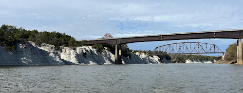
We spent another cold night onboard Dragonfly at anchor. Our Little Buddy propane heater does a nice job of taking the chill off and is very safe, but we don’t sleep with it on. Today’s sunrise cabin temp was 42F, and getting out of bed was tough. Our anchor held particularly well in the river current, and we found out why when we went to retrieve it. Once again our anchor line was fouled around something big on the bottom, and it took a good 30 minutes of pulling from several directions with the outboard and the two of us to free it. We were grateful to save our anchor from the river’s clutches again, and the exertion was a quick way to warm up.
We’re on The River Section, the third portion of the Tenn-Tom Waterway (Bonus Question for our regular readers: What are the other two sections? Answer at end of post). We are now following the natural, winding path of the Tombigbee River (see first pic), except where the Army Corps of Engineers deemed it too curvy and shortened the route with cutoffs. There are about 20 such cutoffs over more than 150 miles, which reduced the total distance of the waterway by almost 30 miles. The longest of these oxbows that were cut off is Rattlesnake Bend, which we passed today (see second pic—the green line at the 14:36 time stamp is the cutoff; the blue line is the original river).
Because we’re on a natural river, the scenery is much nicer, including the White Cliffs of Epes, a one-mile stretch of stunning, 80-foot chalk-white bluffs.
We traveled 49 miles today to Kingfisher Bay Marina in Demopolis, AL, where the Black Warrior River joins the Tombigbee for the final 216 miles to Mobile Bay and the Gulf of Mexico. We’re spending the weekend in port due to a wet forecast, then hope to get to Mobile next weekend.
Bonus Question Answer: The Divide Cut (full credit if you answered “The Ditch”) and The Canal Section are the other portions of the Tenn-Tom Waterway.


No comments:
Post a Comment